


Aqueduc Jacourelle-Goiron-Valbonnette

Berpav
User
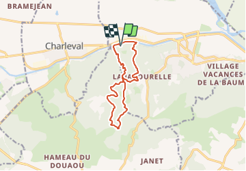

Length
12 km

Max alt
476 m

Uphill gradient
363 m
Km-Effort
16.9 km

Min alt
157 m

Downhill gradient
362 m
Boucle
Yes
Creation date :
2024-01-05 08:20:17.871
Updated on :
2024-01-05 08:21:58.474
3h50
Difficulty : Difficult

FREE GPS app for hiking
 SityTrail
IGN / Geographical institutes
SityTrail Plus
The world is yours!
About
Trail Walking of 12 km to be discovered at Provence-Alpes-Côte d'Azur, Bouches-du-Rhône, La Roque-d'Anthéron. This trail is proposed by Berpav.
Positioning
Country:
France
Region :
Provence-Alpes-Côte d'Azur
Department/Province :
Bouches-du-Rhône
Municipality :
La Roque-d'Anthéron
Location:
Unknown
Start:(Dec)
Start:(UTM)
683152 ; 4843287 (31T) N.
Comments